

IN THIS BLOG
SHARE

Accurate existing-condition information is essential when renovating, retrofitting, expanding, or repurposing an existing building. Yet project teams often begin with outdated drawings, incomplete records, undocumented modifications, or measurements collected from limited field visits.
These gaps can create uncertainty during design development and construction. Even relatively small discrepancies between documented and actual conditions can affect dimensions, equipment locations, clearances, structural relationships, and MEP coordination.
3D laser scanning provides a practical way to capture existing building conditions as detailed spatial data. Instead of relying entirely on manual measurements or legacy drawings, project teams can use laser scanners to capture millions of points across a building and create a measurable point cloud representing the surveyed environment.
This data can then support existing-condition documentation, design development, coordination, renovation planning, and downstream BIM workflows.
Why Existing-Building Documentation Is Often Unreliable
Existing buildings rarely match their original construction documents perfectly.
Over time, buildings undergo renovations, tenant improvements, equipment replacements, structural modifications, MEP upgrades, and other changes that may not be fully reflected in the available drawings.
For example, a project team may receive architectural drawings showing an existing wall layout, while the actual building contains modifications that occurred during previous renovations. Similarly, mechanical and electrical systems may have been rerouted or replaced without corresponding updates to the original documentation.
Common sources of existing-condition uncertainty include:
- Outdated architectural drawings
- Incomplete as-built documentation
- Undocumented renovations or modifications
- Inaccurate dimensions
- Missing MEP information
- Changes to structural elements
- Equipment replacements
- Unknown ceiling and above-ceiling conditions
- Limited access to difficult-to-measure areas
- Multiple drawing revisions with inconsistent information
These discrepancies become particularly important when a new design must connect to existing construction.
A designer developing a renovation layout needs to know not only the approximate location of a wall or piece of equipment, but also how existing elements relate spatially to one another.
That is where accurate reality capture can provide significant value.
Where Traditional Field Measurements Fall Short
Traditional field measurement remains useful for many projects. Tape measurements, laser distance meters, photographs, sketches, and visual inspections can provide valuable information.
However, manually documenting an entire building can become challenging when the project involves complex geometry, large areas, multiple disciplines, or difficult-to-access spaces.
Limited measurement coverage
A conventional survey typically focuses on selected dimensions or areas considered important during the site visit.
If a dimension was not measured, the design team may need another site visit to obtain it.
Human measurement errors
Manual measurements can be affected by:
- Incorrect instrument positioning
- Reading or recording errors
- Inconsistent reference points
- Difficult access
- Misidentified building elements
Even small errors can become significant when multiple dimensions are combined during design.
Complex spatial relationships
Existing buildings often contain dense relationships between architectural, structural, mechanical, electrical, and plumbing components.
Documenting these relationships manually can be time-consuming.
Repeated site visits
When the initial documentation does not contain sufficient information, project teams may need additional site visits.
This can increase survey time, disrupt building occupants, and delay design development.
Difficulty documenting concealed or congested areas
Mechanical rooms, utility spaces, ceiling voids, equipment areas, and congested service zones can be particularly difficult to document through conventional measurements alone.
3D laser scanning does not eliminate the need for professional survey and field verification, but it can significantly expand the amount of spatial information captured during a site visit.
How 3D Laser Scanning Captures Existing Conditions
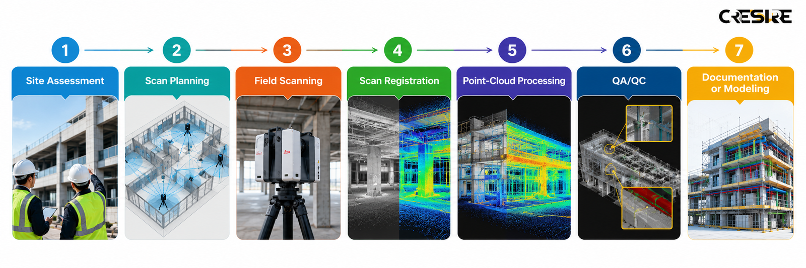
3D laser scanning uses laser-based reality-capture technology to measure the physical environment and generate a dense collection of spatial points.
Depending on the scanner and project requirements, millions of measurements can be captured from multiple scan positions.
The resulting dataset is commonly referred to as a point cloud.
Each point contains spatial information that can collectively represent surfaces and objects within the scanned environment.
1. Site assessment and scan planning
Before scanning begins, the project team identifies:
- Areas to be captured
- Required level of detail
- Critical building elements
- Access limitations
- Registration requirements
- Required deliverables
- Coordination requirements
The scanning strategy should be based on the intended use of the data rather than simply collecting as many scans as possible.
2. Field scanning
Laser scanners are positioned at strategic locations throughout the building.
Multiple scan positions are typically required to capture spaces from different viewpoints and reduce occlusions.
For large or complex facilities, the scanning plan may cover architectural spaces, structural elements, equipment rooms, MEP systems, circulation areas, and other project-specific locations.
3. Scan registration
Individual scans are registered into a common coordinate system.
This creates a unified point cloud that represents the surveyed environment.
Registration accuracy is an important component of the workflow because poorly aligned scans can affect downstream measurements and modeling.
4. Point-cloud processing and QA/QC
The registered data is reviewed and processed to identify issues such as:
- Misalignment
- Unwanted points
- Occluded areas
- Incomplete coverage
- Registration problems
- Data gaps
Quality control helps ensure that the point cloud is suitable for its intended project application.
From Point Clouds to Usable Project Documentation
A point cloud is valuable because it provides a detailed digital representation of existing conditions. However, the raw dataset is not always the final deliverable required by architects, engineers, contractors, or owners.
Depending on project requirements, point-cloud data can support several forms of documentation.
2D existing-condition drawings
Point clouds can be used as a reference for developing:
- Floor plans
- Elevations
- Sections
- Reflected ceiling plans
- Detailed views
- Existing-condition documentation
This can provide design teams with a more reliable reference than outdated drawings alone.
3D visualization
The captured environment can also be reviewed as a three-dimensional dataset.
This allows project stakeholders to better understand:
- Building geometry
- Spatial relationships
- Equipment locations
- Clearance conditions
- Existing architectural elements
BIM modeling
For projects requiring model-based documentation, point-cloud data can serve as the basis for developing an existing-condition BIM model.
Architectural, structural, MEP, or other discipline-specific elements can be modeled according to the project’s required Level of Development (LOD).
This is where a reality-capture workflow can transition into Scan-to-BIM.
Rather than treating Scan-to-BIM as the same thing as laser scanning, it is more accurate to view it as a downstream modeling workflow in which point-cloud information is used to develop a BIM representation of existing conditions.
Applications in Renovation and Retrofit Projects
Existing-condition documentation becomes particularly valuable when project teams are modifying an existing facility.
Building renovations
Renovation projects often involve connecting new construction to existing walls, floors, ceilings, structural systems, and building services.
Accurate existing-condition data can help designers work from current site conditions rather than relying entirely on historical documentation.
MEP upgrades
Mechanical, electrical, and plumbing systems can become highly congested over the life of a building.
Laser scanning can help document existing:
- Ductwork
- Piping
- Electrical equipment
- Mechanical equipment
- Structural elements
- Ceiling conditions
- Service clearances
This information can support MEP planning and coordination.
Healthcare renovations
Healthcare facilities often require renovation while surrounding areas remain operational.
Detailed existing-condition documentation can help project teams understand spatial constraints before developing new layouts or routing systems.
Commercial and tenant improvements
For commercial interiors, reality capture can help document existing layouts, architectural features, ceilings, equipment, and building services before a new tenant improvement design is developed.
Historic and older buildings
Older buildings may have limited or unreliable documentation.
Laser scanning provides a method for capturing the geometry of the existing structure without depending exclusively on historical drawings.
Facility documentation
Owners and facility managers can use accurate spatial documentation to improve their understanding of existing spaces and building assets.
The information may support future renovations, maintenance planning, space management, and facility upgrades.
For example, an aerial view may be appropriate for a large multifamily or mixed-use development where site relationships are important.
A street-level perspective may be more useful for evaluating a commercial building’s façade and entrance.
The principle is simple: Choose the camera angle based on what the viewer needs to understand, not simply on what makes the building look dramatic.
How Accurate Existing-Condition Data Supports Design Coordination
Design coordination depends on the quality of the information being coordinated.
If the underlying existing-condition information is inaccurate, coordination decisions may also be based on incorrect assumptions.
A detailed reality-capture dataset can help project teams identify spatial relationships earlier in the design process.
For example, an MEP designer may need to determine whether new ductwork can pass through an existing ceiling zone without interfering with structural elements or existing utilities.
Instead of relying on isolated measurements, the design team can reference a broader spatial representation of the existing environment.
This can help with:
- Clearance verification
- Equipment placement
- Routing studies
- Existing-to-new connections
- Architectural coordination
- Structural coordination
- MEP coordination
- Constructability reviews
- Renovation planning
Supporting clash detection
When existing-condition information is incorporated into a BIM environment, it can also support coordination and clash detection.
For example, an existing structural beam documented through scanning can be represented in the model and coordinated against proposed ductwork, piping, cable trays, or architectural elements.
This does not mean scanning automatically eliminates clashes. Rather, accurate existing-condition information gives the project team a stronger basis for identifying and resolving potential conflicts during design.
When Should Project Teams Consider Reality Capture?
Not every project requires 3D laser scanning.
The technology becomes particularly useful when the cost of uncertainty is higher than the cost of capturing accurate existing conditions.
Project teams should consider reality capture when:
Existing drawings are outdated
If available drawings cannot be confidently relied upon, scanning can provide current field information.
The building has complex geometry
Irregular structures, complex interiors, large facilities, and complicated MEP environments can benefit from comprehensive spatial capture.
Renovation work involves multiple disciplines
Projects involving architectural, structural, mechanical, electrical, and plumbing modifications may require a more complete understanding of existing conditions.
Site access is difficult
When returning to the site repeatedly would be disruptive or expensive, capturing comprehensive data during the initial survey can provide a valuable reference for subsequent design work.
Existing-to-new connections are critical
Projects involving new construction connected to existing systems can benefit from accurate dimensions and spatial relationships.
The project requires BIM-based existing-condition documentation
If the final deliverable requires a coordinated existing-condition model, point-cloud data can provide a strong foundation for BIM development.
Key Considerations Before Scanning a Building
Successful reality capture begins with clearly defining what the project actually needs.
Before scanning a building, project teams should consider the following.
Define the required deliverables
Determine whether the project requires:
- Registered point clouds
- 2D drawings
- 3D visualization
- BIM models
- As-built documentation
- MEP documentation
- Architectural documentation
- Structural documentation
The deliverable determines the appropriate scanning and processing strategy.
Establish the required accuracy
Accuracy requirements should be defined according to the intended application.
A conceptual planning exercise may have different requirements from detailed fabrication, construction coordination, or survey-controlled documentation.
Determine the required LOD
If a BIM model will be developed from the point cloud, establish the required Level of Development before modeling begins.
LOD requirements can affect:
- Modeling effort
- Element representation
- Project cost
- Delivery schedule
- Required point-cloud detail
Identify areas requiring additional attention
Certain spaces may require greater scan density or additional scan positions because of:
- Congestion
- Obstructions
- Complex geometry
- Limited visibility
- Critical equipment
- MEP intersections
Plan for site conditions
Scanning may be affected by:
- Occupied spaces
- Moving equipment
- Restricted access
- Temporary construction conditions
- Reflective or difficult surfaces
- Safety requirements
A site-specific scanning plan helps account for these conditions before field capture begins.
Establish coordinate and registration requirements
For projects requiring integration with existing drawings, survey data, BIM models, or other datasets, coordinate-system requirements should be established early.
This reduces the risk of alignment problems during downstream documentation and coordination.
Final Thoughts
Conclusion
Accurate existing-condition information provides a stronger foundation for renovation, retrofit, expansion, and facility documentation projects.
Traditional measurements and existing drawings remain valuable, but they may not provide the comprehensive spatial information required for complex existing buildings.
3D laser scanning allows project teams to capture detailed spatial data and create a measurable point cloud representing the surveyed environment. That information can then support existing-condition drawings, visualization, design development, coordination, and BIM modeling.
The greatest value comes from treating reality capture as part of a broader project workflow rather than as an isolated scanning activity.
When properly planned, the workflow can connect:
Existing building → 3D laser scanning → Point cloud → Verified existing conditions → Documentation → BIM modeling → Design and coordination
For projects where accurate existing-condition information is critical, this approach can give architects, engineers, contractors, and owners a more reliable digital foundation for making design and construction decisions.
NDA available