

3D Scan to Revit Services UK
Turn Laser Scan Data Into Reliable Revit Models for Renovation, Retrofit & Coordination
- Native Revit BIM models
- Architectural, structural & MEP modeling
- RCP, E57, LAS and other point cloud formats
- LOD-based modeling
- As-built BIM documentation
- Project-specific QA/QC
150K+
Sq Ft Modeled
100+
Projects
92%
Repeat Client
Trusted by AEC Professionals






3D Scan to Revit Services for UK AEC Projects
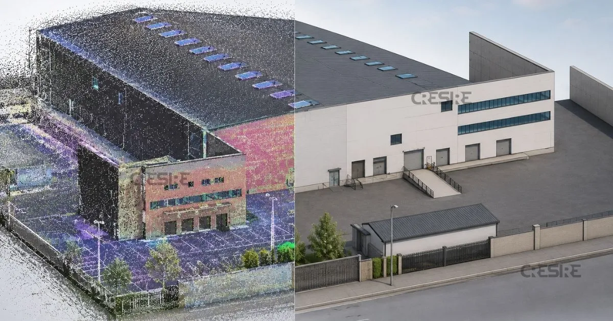
Laser scanning can capture millions of points from an existing building, but the point cloud itself is not always the most practical format for design development and coordination.
Point Cloud to Revit modeling transforms captured survey information into a structured BIM model that architects, engineers and contractors can work with.
CRESIRE develops Revit models from registered point cloud data for existing buildings and infrastructure, with modeling scope defined according to the project’s requirements.
Our services can support:
Architectural Renovations
Develop accurate Revit models of existing buildings from laser scan data to support renovation, refurbishment and extension projects. This gives architects a reliable digital representation of existing conditions before developing proposed designs.
Retrofit Projects
Use point cloud-based BIM models to understand existing building geometry before introducing new systems, upgrades or energy-efficiency measures. This can help teams plan retrofit work around actual site conditions.
Structural Coordination
Model existing structural elements such as columns, beams, slabs and structural walls from scan data to support coordination with proposed architectural and engineering designs. This helps identify spatial constraints before construction.
MEP Coordination
Capture and model visible existing pipes, ducts, equipment and other building services to create a coordinated representation of existing MEP conditions. This is particularly useful when new services need to be routed through constrained existing spaces.
As-Built Documentation
Convert surveyed point cloud data into structured Revit models that document existing or completed building conditions. These models can provide a more usable digital record than standalone point cloud data.
Facility & Asset Management
Where the project requires it, BIM models can incorporate relevant asset and equipment information alongside the modeled geometry. This can support future maintenance, space management and facility operations.
How Point Cloud to Revit Converts Laser Scans Into BIM Models
A point cloud contains the captured geometry of the surveyed environment, but the points themselves do not automatically become walls, floors, doors, pipes or structural elements in Revit.
Our Scan to Revit modeling process interprets the available scan data and develops the appropriate native Revit elements.
The resulting model can then be used within the broader BIM workflow for design, coordination, documentation or other agreed project applications.
The level of modeling depends on the required LOD, project scope, scan quality and information requirements.

What We Model From Point Cloud Data
CRESIRE can develop multidisciplinary Revit models from laser-scanned building information.
Architectural Scan to Revit
_____________________________________
- Walls
- Floors
- Roofs
- Ceilings
- Doors
- Windows
- Stairs
Structural Scan to Revit
_____________________________________
- Columns
- Beams
- Slabs
- Structural walls
- Framing
- Foundations
- Other visible structural elements
MEP Point Cloud to Revit
_____________________________________
- Pipework
- Ductwork
- Equipment
- Fixtures
- Mechanical systems
- Electrical and service elements
Point Cloud Formats We Accept
We can work with commonly used point cloud formats and project-specific scan data, including:
RCP
RCS
E57
LAS
PTS
PTX
The suitability of the data depends on factors such as registration, density, coverage, coordinate information and the visibility of the elements that need to be modeled.
If you are unsure whether your scan data is suitable for Revit modeling, send the files for a preliminary review and we can assess the available information before quoting.
Our Scan to Revit Workflow
We follow a structured workflow designed to reduce assumptions between the point cloud and final BIM deliverable.
Point Cloud & Scope Review
Point Cloud Preparation
Revit Project Setup
Revit Model Development
Coordination & Model Review
QA/QC & Final Delivery
What Determines the Accuracy of a Scan to Revit Model?
A point-cloud-based BIM model can provide highly reliable existing-condition information, but the achievable modeling accuracy depends on the quality of the source data and the agreed project requirements.
Important factors include:
Point cloud registration quality
Scan density
Scan density
Survey/control information
Obstructed Building Areas
Required project tolerance
Modeling scope
LOD Information Requirements
This is why we don’t treat accuracy as a single universal number for every project.
The model is developed to the agreed project requirements and based on the information captured in the available scan data.
Where the scan cannot clearly establish an element, the issue can be identified rather than introducing unsupported assumptions into the model.
Case Studies
Recent Point Cloud to BIM projects
Point Cloud to Revit & CAD Drawings
5400
SQ FT
LOD 300
accuracy
1W
Delivered
Scan to BIM for a Chemical Plant
21500
sq ft
LOD 400
accuracy
2W
Delivered
Point Cloud Scans to LOD 350 Model
28,000
Sq Ft
LOD 350
Accuracy
2M
Delivered
Revit Model Deliverables
The final deliverables depend on the agreed project scope and requirements.
Typical outputs can include:
|
Deliverable
|
Application
|
|---|---|
|
RVT
|
Native Revit BIM model
|
|
IFC
|
Open BIM coordination/exchange
|
|
DWG
|
2D drawings extracted from the model
|
|
Plans
|
Existing-condition documentation
|
|
Elevations
|
Façade and vertical documentation
|
|
Sections
|
Building and coordination documentation
|

100+
Projects Completed
0.02%
Rework Rate
Models can be developed to the required LOD and project-specific BIM standards.
Where a project requires as-built or asset information, the required information parameters should be defined as part of the project scope rather than assuming that a higher LOD automatically means a more useful model.
Scan to Revit Use Cases in the UK
Existing buildings present a particular challenge when original drawings are incomplete, outdated or no longer representative of the building.
Renovation & Refurbishment
Building Extensions
Heritage & Historic Buildings
MEP Upgrades
As-Built Documentation
Facility Management
24-HOUR QUOTE RESPONSE
Have Point Cloud Data Ready?
Whether you are an architect, surveyor, laser scanning company, engineer or contractor, we can review your point cloud data and determine the appropriate Scan to Revit / Point Cloud to BIM workflow for your project.
Send us your RCP, E57, LAS or other available scan data and project requirements. We’ll review the information and provide a tailored proposal based on the required scope, LOD and deliverables.
enquiry@cresireconsulting.com
NDA available
FAQ
Frequently asked questions
How accurate should a Scan to Revit model be for renovation and retrofit projects?
Accuracy specifications vary based on the use of the model. The specifications for coordinating design may need to differ from those of fabrication or facility management. It is important to set the accuracy specifications of the model early.
What information should be checked before converting point cloud data into Revit?
Prior to modelling, the project team should ensure that the quality of scan registration, site coverage, coordinate system, control points, and any regions affected by occlusion have been checked. Inadequate data can affect the model and coordination efforts.
When is a Revit model more valuable than traditional as-built drawings?
When several disciplines have to work together in a pre-existing structure, the model in Revit becomes quite useful. Clash detection, design development, quantity take-off, and modifications become possible with the use of BIM models unlike static drawings.
Can Scan to Revit support historic and heritage building projects in the UK?
Yes. Laser scanning is widely used on heritage assets because it captures irregular geometry that would be difficult and time-consuming to document using traditional surveying methods.
How do BIM teams handle areas that were not captured during scanning?
BIM teams that have experience in BIM detect occlusions while reviewing projects and ensure proper documentation about their assumptions or limitations. Sometimes, additional scanning is recommended.
What Level of Detail (LOD) should be specified for a Scan to Revit project?
Different projects have different LODs. This is because a project that requires a BIM for planning and coordinating design processes will be very different from another one that needs it for fabrication, asset management, or facilities management.
How does Scan to Revit reduce project risk during refurbishment?
Using a correct BIM model while building will ensure that there are no surprises on the construction site for the architect, the engineers, and the contractors.
What deliverables can be produced from a Scan to Revit model?
Considering the needs for the project, there could be different types of deliverables, including Revit model, IFC file, 2D plan, elevation, section, schedule, coordination model, and facilities management data.