High-Precision Scan to CAD Services for Accurate As-Built Drawings
Convert laser-scanned point cloud data into accurate 2D CAD drawings (DWG/DXF) for renovation, retrofit, and facility management projects.
QA/QC Verified Deliverables LOD 200-500 2-12 Day Turnaround

⭐ Trusted Globally by surveyors, architects, and construction professionals

What is Scan to CAD?
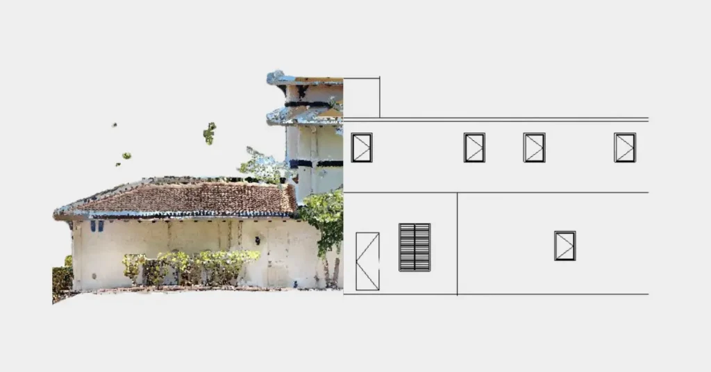
Scan to CAD or 3D point cloud to AutoCAD involves processing 3d laser scan (LiDAR) into unified point cloud data that is used for creating precise 2D Architectural, Structural and MEP CAD drawings.
This includes floor plans, elevations, sections, reflected-ceiling plans, structural framing plans, and MEP drawings. Point Cloud to CAD conversion is useful for architects, engineers and contractors for creating precise as-built drawings of buildings and site.
At CRESIRE, we have experienced CAD professionals with robust Architectural, Civil and MEP engineering backgrounds. We assist AEC professionals in converting raw scan data into structured and editable AutoCAD drawings Services for smooth project execution.

Our Point Cloud to CAD Services
|
Architectural CAD Drawings
|
Structural CAD Drawings
|
MEP CAD Drawings
|
|---|---|---|
|
Floor Plans
|
Beam Layouts
|
HVAC Layouts
|
|
Elevations
|
Column Grids
|
Electrical Drawings
|
|
Sections
|
Foundation Plans
|
Plumbing Systems
|
|
Reflected Ceiling Plans
|
Structural Sections
|
Fire Protection Layouts
|
Point Cloud to BIM Deliverables
DWG
DXF
Drawing Types
2D Floor Plans
Elevations
Sections
Site Plans
Key Benefits of 3D Scan to CAD Services
- Work with millimeter-level accurate drawings that you can rely on site
- Move projects forward faster as compared with traditional manual surveys
- Cut down design errors early and avoid costly rework during construction
- Plan renovations with much clearer visibility of existing site conditions on CAD drawings
- Get reliable 2d CAD drawing documentation of a building without unnecessary costs

Our Scan to CAD Workflow
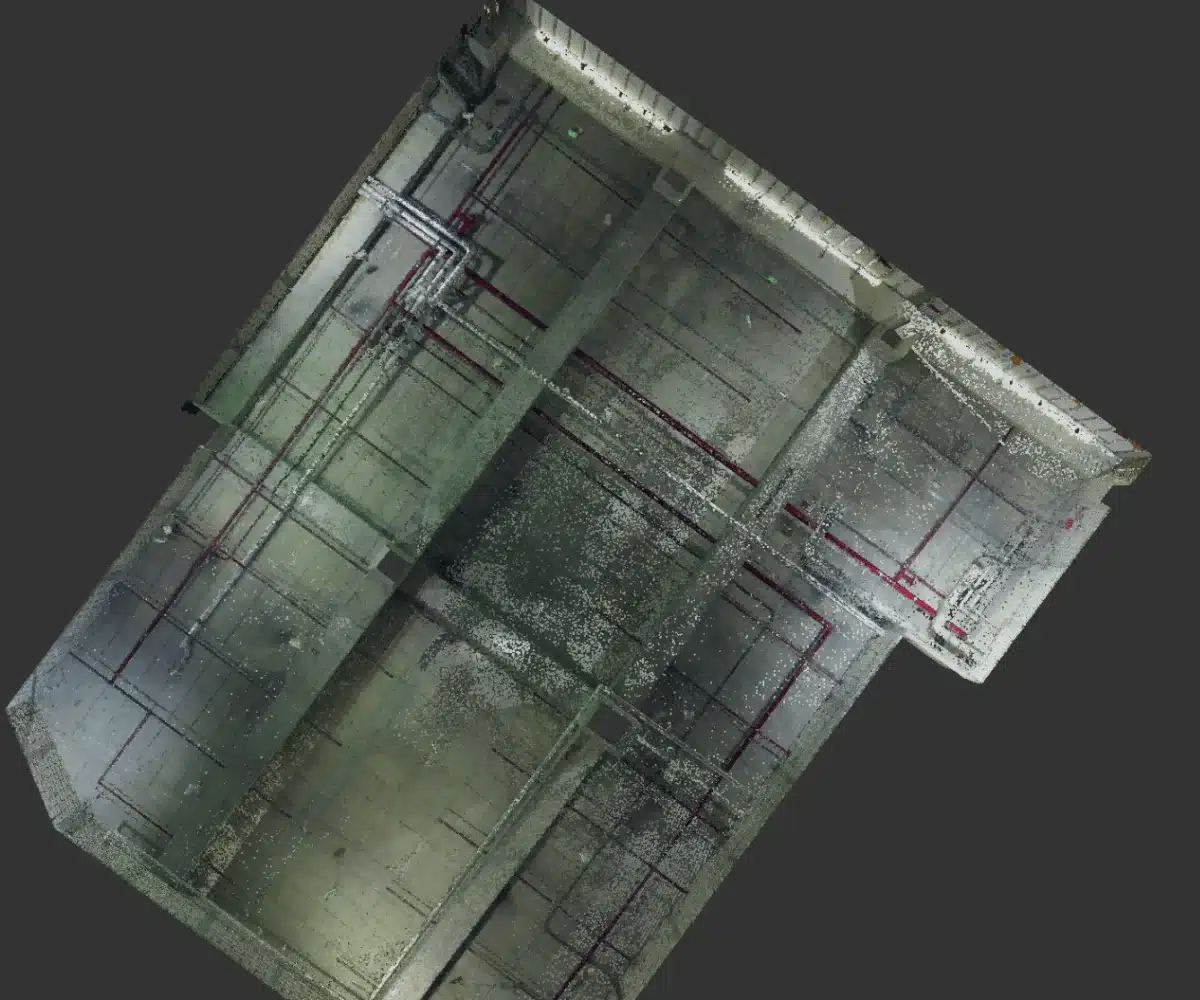
We receive the laser scanned data of a building/existing site from our clients. The most common formats of the point cloud data include e57, RCP, LAS and XYZ formats.
Our team aligns and registers the point cloud data into a unified RCS file. This step ensures that the point cloud data is ready for CAD conversion services.
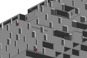
We import the processed point cloud into software like AutoCAD or Revit. After this, the data is finally ready for 2D CAD drafting services.
Our expert AutoCAD drafters and technicians measure, trace and draft accurate 2D drawings directly from the point cloud data in architectural, structural and MEP disciplines.
The QA/QC manager review the final CAD drawings services for accuracy and inclusion of all required elements are included in the final drawings.
Industries We Serve
Architecture & Design Firms
Construction Companies
Amphitheater and Exhibition halls
Laser Surveying
Healthcare & Hospitality
Civil Engineering
Mechanical, Electrical & Plumbing
Building Information Modeling (BIM)
Real Estate Developers
Industrial Facilities
Heritage & Historical Projects
BIM Technology Stack


Use Cases of Point Cloud to CAD
- Supports retrofit & expansion planning with a clear understanding of site conditions
- Preservation of heritage properties by precisely documenting materials & design details for potential future renovation
- Correct levels and locations of MEPF element in reflected ceiling plans (RCP) of sites
- AutoCAD plans and sectional drawings of exhibition halls for effective event planning
- Supports major architectural renovation projects using as built architectural drawings
- Helps streamline facility management with precise location and details of elements
- Enables smoother coordination for clash-free construction planning
Why Choose CRESIRE for 3D Scan to CAD?
- Backed by experienced CAD and BIM professionals with robust Architectural & Engineering backgrounds
- Delivering high quality editable CAD outputs for complex architectural, engineering and construction projects
- Providing quick turnaround time by prioritizing production on projects
- Offering flexible and customized solutions tailored to each project
Our Latest Projects of Scan to CAD

Point Cloud to Architectural Drawings
New York, USA
Architectural Drawings From e57 Point Cloud Data
XYZ Data

Point Cloud to AutoCAD Drawings for Office Renovation
California, USA
Architectural Plans and Exterior Elevations
2D CAD Plans & Elevations
Scan to CAD Conversion of a Warehouse
California, USA
Scan to CAD Conversion of a warehouse building project
Detailed CAD drawing
Serving Every Country/Continent
Get A Quote Now
Frequently Asked Questions - FAQs
What is Scan to CAD?
Scan to CAD is the process of converting point cloud data into 2D CAD drawings.
How accurate is Scan to CAD conversion?
Accuracy depends on scan quality but typically achieves millimeter-level precision.
What file formats do you provide?
We deliver DWG, DXF, and PDF formats.
How long does the process take?
Turnaround time depends on project size and complexity.
What are the benefits of using Scan to CAD conversion services?
The advantages include; smooth planning for renovation because you have precise dimensions of building elements in editable DWG format. Moreover, point cloud to cad drafting eliminates guesswork for facilities or building management.
Can I convert point cloud data directly into a CAD model?
Yes, point cloud data can be converted into a CAD model. The process is conducted software like Autodesk Recap Pro, AutoCAD or Revit. The process involves cleaning, importing and modeling the point cloud data into accurate 2D AutoCAD drawings. Many architects and engineers across the globe use point cloud to CAD services on renovation, retrofit and historical preservation projects.